


Last week, the Science and Technology Directorate (S&T) joined colleagues from the National Oceanic and Atmospheric Administration (NOAA), NASA, and the National Weather Service for an immersive extreme weather risk and preparedness workshop at the University of Oklahoma’s National Weather Center. As the frequency and impacts of these weather events—whether floods, hurricanes, tornadoes, wildfires, blizzards, or ice storms—increase, so too does the need for a greater understanding of available data and trend patterns, so we can collectively ensure the safety of our communities, citizens, and critical infrastructure.
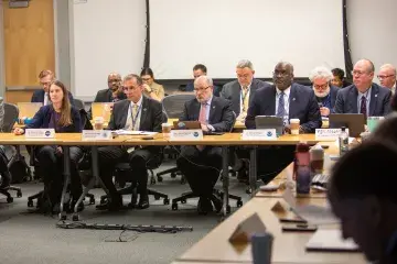
The one-day workshop brought together more than 50 scientists and leading experts from across the Department of Homeland Security (DHS) and the federal government, as well as first responders from around the country, to identify new operational strategies that will ultimately better prepare agencies to mitigate the effects of future extreme weather events. Lessons learned and best practices from the workshop will soon be released in a written report that summarizes the information, discussions, and findings that were shared at this workshop. The report will inform DHS’s and S&T’s own next steps, both through research and development (R&D) and operational action.
With much work still on the horizon, I can report that S&T is actively funding, developing, and deploying several state-of-the-art weather-related tools and technologies. At a time when the effects of climate change and unusual weather are becoming increasingly severe, having access to the right resources and the ability to process and quickly share critical information can be the difference between life and death.
Here is a brief overview of a handful of S&T-funded resources and capabilities currently underway to support response agencies in the field.
Wildland Fire Sensors
S&T’s wildland fire sensors—currently being piloted in the U.S. (including in communities in California, Oregon, and Colorado), Canada, Germany, and Peru—alert agencies to early ignitions, allowing responders to get to the source and suppress the blaze before it spreads out of control. Advanced notice of an imminent fire hazard could also grant time needed for communities to make life-saving evacuation decisions. Stay tuned for an announcement of a very important new pilot, as well as new functionality, of the fire sensors in coming weeks.
Wildland Firefighter Respirator
S&T’s state-of-the-art wildfire respirator is small, lightweight, and easy to wear, and is designed to protect wildland firefighters from the various fire-borne particulates and toxic gases they may encounter in the field. S&T has worked with the California Department of Forestry and Fire Protection, International Association of Fire Chiefs, U.S. Forest Service, and fire departments around the country to develop, test, and evaluate the technology, which is now undergoing NIOSH and NFPA certifications.
National Emergency Response Information System (NERIS)
S&T is supporting FEMA and the U.S. Fire Administration with developing and implementing NERIS, a secure, cloud-based, interoperable fire information and analytics platform designed to provide real-time empirical data and information that will improve the ability to quickly and effectively prepare for and respond to a wide range of emergencies in the field.
Wildland Urban Interface Integration Model
S&T continues to collaborate with FEMA, the Federal Communications Commission, and the wireless industry to improve capabilities for Wireless Emergency Alerts. Just this past summer, we demonstrated a new enhancement to existing alerting capabilities that will ultimately send critical information to the public via in-vehicle infotainment consoles and navigational mapping systems. Then, just like being guided to the best detour to get around a traffic accident, drivers will be able to follow the directions to safely evacuate away from a wildfire impact zone.
Rhode Island Coastal Hazards Analysis Modeling and Prediction (RI-CHAMP)
S&T’s Coastal Resilience Center, a DHS Center of Excellence, is working with stakeholders in Rhode Island to implement RI-CHAMP, a next-generation weather prediction and forecasting tool that combines state-of-the-art storm modeling applications with weather-related hazard databases. The platform, which was built using code from the ADCIRC Prediction System, enables users to predict the potential impact of coastal storms in real time. Several agencies, including the Rhode Island Emergency Management Agency, recently incorporated RI-CHAMP into its storm prediction suites, and this month a capabilities demonstration was given to senior leaders at the U.S. Coast Guard.
Exploitation of Mesonets for Emergency Preparedness and Response in Weather Extremes (EMPOWER)
S&T is collaborating with the State University of New York (SUNY) at Albany to develop and implement improved weather forecasting technologies and systems that federal, state, and local first responders can rely on in the field. The EMPOWER pilot program will integrate and leverage SUNY Albany’s cutting-edge artificial intelligence, data visualization, and analytic capabilities, along with real-time weather data provided by local mesonets (networks of regional automated weather and environmental monitoring weather stations), ultimately providing first responders with real time assessments of changing weather conditions and how they may impact relevant communities and critical infrastructure.
This month’s workshop was only the beginning of an ongoing conversation about how science and technology plays a role in disaster response, today and tomorrow. These examples are just the tip of the iceberg; by bringing together the nation’s leading minds and leveraging critical data, we are uniquely positioned to help communities and emergency managers weather any and all storms.
Visit our Community and Infrastructure Resilience page to learn more about how we safeguard against extreme weather threats and our First Responder Capability page to take a deeper dive into the various ways S&T supports response agencies.